Update about blog

photo from the internet
Showing posts with label George Rogers Family Tree. Show all posts

Thursday, December 10, 2020

Another old photo - for an American patriot


 Unveiling by DAR of the Spencer Clack memorial in Sevierville, TN, 1937.

The Sevier County Court House in 2018

And the memorial stone still stands by its side...


I was able to just walk up to it to get this closeup of the plaque.

He was my great times 5 grandfather...his daughter, Catharine Clack married Rev. Elijah  Rogers, who had a son Micajah Rogers, who had a son, George Washington Rogers, who had a son William Sandford Rogers, who had a son George E. Rogers, who had a son George E. Rogers Jr. who was my father.


Thursday, January 31, 2019

Movement into still photos

I've already posted some old home movies changed into still photos.
But I'd love to share this one series with you, as prompted by Sepia Saturday this week.

Home movies/transformed again (Repost from January 29, 2015)

My dad started taking home movies in the 40s, with a spring wound Keystone projector.  It took 16 mm rolls of film, but when the roll was finished you'd take it out and insert it again and run it through the camera again, getting two 8-mm runs.  Always doing the switch in a closet so the film didn't get exposed, of course.

We had mainly black and white photos, but there are some surprising ones in color.

My dear son, Russ, took the originals and had Walmart's genius people put them into a DVD and then showed them to all my offspring at my 70th birthday.  It was probably pretty boring, especially with the strange sound background the Walmart guys had added.

So last night I pulled out the video, which hadn't been of any interest for years, and decided it would be nice to transform it into some stills so I could share them (and archive them) here.

Ever try to take pictures of a TV show?  Right...the black bar of death crossed most of the attempts, even when the shot was paused.

No, I didn't want to copy into a video format either.  I may try that sometime, but not yet.

Anyway, out of my attempts, and from the first 12 clips, I did get some good shots, though the originals were a bit fuzzy.  I don't know if this was original resolution, or not having a good TV screen.  And I've since reduced the resolution so I can post them here easily.  Ever notice how long it takes to post 2m photos here?

So I'll give you first a series of clips of my grandparents.


 Ada Swasey Rogers and my grandfather George Elmore Rogers, taken in about 1945.  She was around 59 and he was 68 at that time.


Location is their home in Houston, Texas, which they might have just moved to, as 3 years previously (when I was born) they had lived in San Antonio, TX.

My parents and myself were visiting from Dallas, TX.

Their sons Chauncey and George (my father) were having a good time playing with various cameras, and included catching each other telling stories.  Since the camera wound down after about a minute, they were short stories!  More next time!


I posted a lot more stills from home-movies in the following posts in 2015.

Tuesday, August 13, 2013

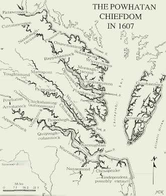
From Powhatan to Chief Bass

More on the Bass family...at least those who have been recognized as Nansemond Native Americans.

My connection is through Elizabeth "Bettie" Bass, my grandfather's mother. 
Here's a picture of one of the recent Chiefs of the Nansemond Nation.

And another picture of Chief Earl Bass (1910-1996) ...


A bit more deatils of  the stories...

Our Stories by Paul Clancy

My Columns in The Virginian-Pilot

August 22, 2010

One of these days I’m going to Suffolk’s historic area. Easy, you say? Well, not the way I’m traveling.

Like those who visited the town in centuries past, I’ll go by water. And that’s not so simple. It must be 15 miles along the wide, then narrow and twisty, Nansemond River. The charts show a high-voltage power line just past Dumpling Island with a 40-foot clearance. And then, just short of town, the 35-foot Rte. 58 bridge. OK for most power boats, but I’m going to have to anchor near the island and putt-putt the rest of the way to town.

But it’s worth it. This place is afloat in history.
I’ll take note, for starters, that Dumpling Island is where the Nansemond Indians had their sacred place – before it was ruined by those heavy handed colonials. John Smith tried to set up an outpost there but sent an oaf named John Martin to run it. Martin attacked the Indians, looted and burned their houses and temples, despoiled their dead and seized their corn. The Nansemonds retaliated and drove the white men back to Jamestown, but later, after bloody but failed uprisings, the tribe was driven from its ancestral lands.

During the long slog up the river, I’ll no doubt curse the day in 1742 that the colonial legislature created the town about as far upriver as you can go. Why not a little settlement at Reid’s Ferry where the first church of the Upper Parish of Nansemond had been built? Or the land where the politically connected Richard Bennett held a couple thousand acres? Originally, when the Jamestown folk decreed that there should be ports, Nansemond Town was created at the point where Bennett’s Creek joins the river. It didn’t last.

What did last was the place where John Constant, possibly from Hampshire, England, built a wharf and warehouse around 1720. From there, he exported tobacco, grains and salt on ships bound for Europe. It would have taken, I’m guessing, at least a couple of tide cycles for the ships to both gain and quit Constant’s Wharf.

Suffolk historian Kermit Hobbs says he thinks the location worked because it was close to the farmers who brought their produce to market, and close to the Great Dismal Swamp where timber was turned into shingles.

The little settlement prospered and in 1742 became a town, but the name was changed from Constant’s Wharf to Suffolk in honor of Gov. William Gooch’s home county in England.

It seems that someone opened the floodgates to history when Suffolk was created, bringing the Revolutionary War and the Civil War to its doorstep. British troops marched into town in May 1779 and turned it into an inferno as combustible material in waterfront warehouses ignited. Eighty years or so later, Union forces rode into town, set up headquarters at the extravagant Riddick’s Folly mansion and endured a year-long siege that ended when the Confederates marched off to Gettysburg.

Railroads from just about every point in Virginia made Suffolk a major hub. The Seaboard Station Railroad Museum has an intricate model train setup that shows the old town.

It all started with John Constant. His plantation, called Constantia, survived both wars but was eventually crowded out by Cedar Hill Cemetery. There’s a replica of the house, I’m told, on West Washington Street.

What has survived is Constant’s Wharf Public Park and Marina, a new centerpiece for the city, next to the Hilton Garden Inn. Hmm, I could cruise up to the marina of a summer evening, take in a TGIF concert at the park, dine at one of the town’s trendy restaurants, take in a play at the Suffolk Center for Cultural Arts, and then, since there’s no place to sleep in a dinghy, rough it at the Hilton.

In May 1863, Harper’s Weekly published this illustration of Constant’s Wharf in Civil War-era Suffolk.


Keziah Dennis, c.1899
Pamunkey Tribe
Smithsonian Institution #888

 The Chiefdom of Powhatan, 1607 with the Nansemond tribal area in center bottom of map