Update about blog

August 8th sunset over Hogback Ridge and Heron Peak. Durango CO with air quality warnings of "ozone" or possibly smoke from wildfires. I kept the windows closed.
Showing posts with label My Bass Family Tree. Show all posts

Saturday, August 17, 2013

My Bass Family Tree,


My grandfather (my father's father): George Elmore Rogers, Sr., born in Galveston, Texas, died in Houston, Texas.


His mother: Elizabeth Bettie Bass Rogers (1860-1924) (my great-grandmother) born in Old Waverly, San Jacinto County, Texas, died in Galveston,Texas


Her father: Colonel Richard Bass ( 1819-1880) born in Perry County, Alabama, died in Waverly, Walker County, Texas.

Not my great great grandfather, but a Confederate pioneer

His father: John Bass (1784-1820) born in Wayne County, NC, died in Perry County, Alabama.

Not John Bass, but a portrait from 1800s

His father: Edward Bass (v.1761-1802) (birth date and place not yet substantiated, could be Craven or Wayne County, NC; He died in Wayne County, NC.


Not Edward Bass, but an outfit worn around 1770
Sarah Bass 1764-1849 (the death date isn't the same as Edward's wife, but the birthdate is right)


His father: Richard Bass (1732-1793) born in Craven County, North Carolina. He died in Wayne County, North Carolina (SEE note below about Waynesborough)    He also was in the Revolutionary War, but I'll talk about that when I honor his birthday.


Not my relative...George Romney's Young Man with a Flute wears a gold figured waistcoat under his coat, Dallas Museum.

His father: Andrew Bass (1698-1770) born in Norfolk Independent City, Nansemond County, Virginia.

His father: Richard Taylor Basye (1658-1722) born in Norfolk Independent City, Nansemond County, Virginia

His father: John Basse (1616-1699) born in London, Middlesex County, England,  and WIFE: Elizabeth Basse, (a.k.a. Kesiah Tucker, Native American), (1618-1676) born in Kecaughton, Nansemond County, Virginia

NOTE on Richard Bass and Waynesborough... Wayne County NC was the place Richard Bass died in 1793.  His uncle Dr. Andrew Bass, b.1735, d. 1791, apparently was one of the early founders of Waynesborough, as per Wikipedia
Prior to 1730, Native Americans were the only known occupants of the territory now known as Wayne county. Settlers trickled into the territory, but there was no general movement of immigration until after 1750. Wayne County was established on November 2, 1779 from the western part of Dobbs County. It was named for "Mad Anthony" Wayne, a general in the American Revolutionary War.  By 1782 the commissioners were named. In 1787 an act was passed establishing "Waynesborough on the west side of the Neuse River on the land of Doctor Andrew Bass where the courthouse now stands."

... Waynesborough grew quickly into a bustling town. Its location along the Neuse River promoted plantation growth and successful river boat businesses. Stage coaches brought much activity and many passengers to the town, many of whom enjoyed the local taverns.
Built just over a mile away in 1839, the Wilmington-Weldon Railroad led to the emergence of Goldsboro, a town built directly along the tracks. Residents of Waynesborough began to move their homes and businesses into the new town. Within a decade, Waynesborough declined and never again recovered. By 1865 only five buildings remained in Waynesborough, all of which were burned by Union Forces in the Civil War.
Union Church, Old Waynesborough, NC
There's now an effort to establish Old Waynesborough as a tourist attraction.  Don't miss the irony of the building above depicted, after the Union Army had destroyed all the buildings remaining in Waynesborough, so my question is, where did this church come from?  Maybe built right after the Civil War?

I'm 11 generations removed from a full blooded Native American ancestor.  That doesn't give me a very big percentage.  And I'm not forgetting that most of my ancestors were Western Europeans mainly from England.  I just have learned about great grandmother, Bettie Bass' grandmother however many times removed, Elizabeth Tucker Basse, and am thrilled.


Tuesday, August 13, 2013

From Powhatan to Chief Bass

More on the Bass family...at least those who have been recognized as Nansemond Native Americans.

My connection is through Elizabeth "Bettie" Bass, my grandfather's mother. 
Here's a picture of one of the recent Chiefs of the Nansemond Nation.

And another picture of Chief Earl Bass (1910-1996) ...


A bit more deatils of  the stories...

Our Stories by Paul Clancy

My Columns in The Virginian-Pilot

August 22, 2010

One of these days I’m going to Suffolk’s historic area. Easy, you say? Well, not the way I’m traveling.

Like those who visited the town in centuries past, I’ll go by water. And that’s not so simple. It must be 15 miles along the wide, then narrow and twisty, Nansemond River. The charts show a high-voltage power line just past Dumpling Island with a 40-foot clearance. And then, just short of town, the 35-foot Rte. 58 bridge. OK for most power boats, but I’m going to have to anchor near the island and putt-putt the rest of the way to town.

But it’s worth it. This place is afloat in history.
I’ll take note, for starters, that Dumpling Island is where the Nansemond Indians had their sacred place – before it was ruined by those heavy handed colonials. John Smith tried to set up an outpost there but sent an oaf named John Martin to run it. Martin attacked the Indians, looted and burned their houses and temples, despoiled their dead and seized their corn. The Nansemonds retaliated and drove the white men back to Jamestown, but later, after bloody but failed uprisings, the tribe was driven from its ancestral lands.

During the long slog up the river, I’ll no doubt curse the day in 1742 that the colonial legislature created the town about as far upriver as you can go. Why not a little settlement at Reid’s Ferry where the first church of the Upper Parish of Nansemond had been built? Or the land where the politically connected Richard Bennett held a couple thousand acres? Originally, when the Jamestown folk decreed that there should be ports, Nansemond Town was created at the point where Bennett’s Creek joins the river. It didn’t last.

What did last was the place where John Constant, possibly from Hampshire, England, built a wharf and warehouse around 1720. From there, he exported tobacco, grains and salt on ships bound for Europe. It would have taken, I’m guessing, at least a couple of tide cycles for the ships to both gain and quit Constant’s Wharf.

Suffolk historian Kermit Hobbs says he thinks the location worked because it was close to the farmers who brought their produce to market, and close to the Great Dismal Swamp where timber was turned into shingles.

The little settlement prospered and in 1742 became a town, but the name was changed from Constant’s Wharf to Suffolk in honor of Gov. William Gooch’s home county in England.

It seems that someone opened the floodgates to history when Suffolk was created, bringing the Revolutionary War and the Civil War to its doorstep. British troops marched into town in May 1779 and turned it into an inferno as combustible material in waterfront warehouses ignited. Eighty years or so later, Union forces rode into town, set up headquarters at the extravagant Riddick’s Folly mansion and endured a year-long siege that ended when the Confederates marched off to Gettysburg.

Railroads from just about every point in Virginia made Suffolk a major hub. The Seaboard Station Railroad Museum has an intricate model train setup that shows the old town.

It all started with John Constant. His plantation, called Constantia, survived both wars but was eventually crowded out by Cedar Hill Cemetery. There’s a replica of the house, I’m told, on West Washington Street.

What has survived is Constant’s Wharf Public Park and Marina, a new centerpiece for the city, next to the Hilton Garden Inn. Hmm, I could cruise up to the marina of a summer evening, take in a TGIF concert at the park, dine at one of the town’s trendy restaurants, take in a play at the Suffolk Center for Cultural Arts, and then, since there’s no place to sleep in a dinghy, rough it at the Hilton.

In May 1863, Harper’s Weekly published this illustration of Constant’s Wharf in Civil War-era Suffolk.


Keziah Dennis, c.1899
Pamunkey Tribe
Smithsonian Institution #888

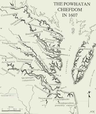
 The Chiefdom of Powhatan, 1607 with the Nansemond tribal area in center bottom of map